 Home
Home Browse
 Close
Close Events
 Maps
Maps Email
Email Brightspace
 eCampus

Dead Horse Point State Park
by Robbie Arnone and Ian Feeney
by Brianna Grenier, 2014.
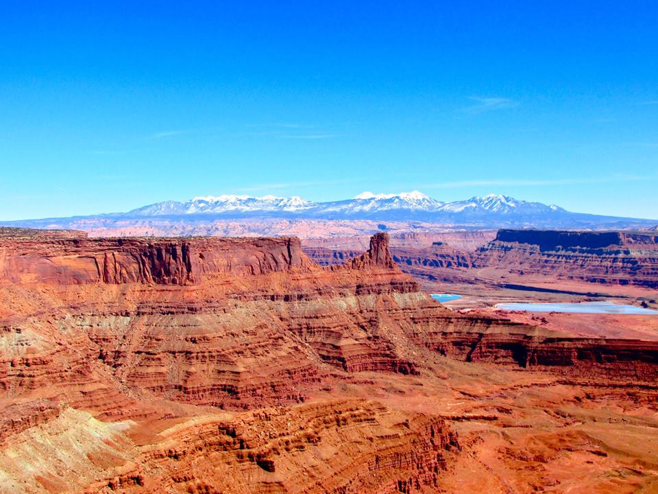
Dead Horse Point State Park is located in Southern Utah southeast of the town of Moab and approximately 250 miles from Salt Lake City. The exposed formations range from the Kayenta Formation (184-188mya) at the top, down to the Cutler group (270-285mya) at the bottom. Most of the rocks visible from Dead Horse Point are sedimentary. These different layers were deposited in ancient oceans, extinct deserts, and in freshwater lakes, streams, and floodplains. Despite the abundance of sedimentary rocks present, some rocks visible from Dead Horse Point are of igneous is origin, including the La Sal Mountains. Other formations are metamorphic, having been changed from their original form by heat and pressure within the Earth’s interior. Over time, the Colorado River slowly carved its way through the strata, revealing formations visible today.
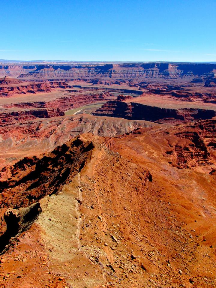
Within sight surrounding Dead Horse Point are the Tertiary La Sal, Abajo, and Henry Mountains, formed 48 to 25 Million years ago (Nelson et. al. 1992). These mountains are composed of diorite, derived deep within the Earth, which pushed through the overlying sediments. Over millions of years of erosion, these igneous intrusions, called laccoliths, became exposed. These were then shaped by glaciers during the last glacial maximum, approximately 20,000 years ago, forming the jagged peaks and steep valleys.
Geologic Sequence:
- Navajo Sandstone: This layer was deposited during the early Jurassic period (Doelling and Thomas, 2000) and large scale cross stratification from Aeolian sediments dominate this formation. White to pinkish cliffs and rounded domes were formed from shifting sand dunes and represent an ancient erg. There is well developed cross bedding potholes, arches, and natural bridges. This layer is visible from, but not present at, Dead Horse Point.
- Kayenta Formation: This formation was deposited during the early Jurassic period, 184-188 m.y.a. (Doelling and Thomas, 2000). This formation was deposited by rivers and floodplains. It is comprised of reddish, gray, and lavender sandstone, shale, and siltstone forming ledges. It is the cap rock to Dead Horse Point and contains potholes, dinosaur tracks, and a rich fossil fauna including early mammals, turtles and dinosaurs.
- Wingate Sandstone: The Wingate sandstone was deposited during the earliest Jurassic period. (Doelling and Thomas, 2000). Large scale aeolian cross-stratification from an ancient erg formed this layer. The cliff faces are often streaked with desert varnish.
- Chinle Formation: The Chinle formation was deposited during the late Triassic period (Doelling and Thomas, 2000). The sediment that makes up this formation was deposited by non-marine fluvial environments. It is made up of slope-forming reddish, brown, gray and greenish layers of mudstone, shale, and sandstone. This formation also contains petrified wood, volcanic ash, and uranium.
- Moenkopi formation: The Moenkopi formation was deposited during the lower Triassic period (Doelling and Thomas, 2000). Vast tidal flats and floodplains are responsible for the sediments left behind. It is brick red, reddish brown mudstone and sandstone. Ripples, raindrop marks, and mud cracks are visible in this layer.
- Cutler Group: The Cutler Group was deposited during the Permian Period (Doelling and Thomas, 2000). Fluvial processes and coast deposits dominate this layer.
- White Rim Sandstone: Light-colored sandstone formed in offshore sand bars, beach sands and coastal dune environments during middle Permian time (Doelling and Thomas, 2000). Found almost exclusively in the Canyonlands area.
- Organ Rock Shale: Soft, dark red shale and siltstone deposited in coastal lowlands and tidal flats. Erodes into ledges and slopes except for when it is capped by harder sediments, which then creates towers and pinnacles.
- Lower Cutler Formation: This layer is exposed at river level and is grey and reddish limestone, sandy shale and sandstone cliffs. It was deposited in shallow seas, coastal plains and freshwater floodplains.
Important Biology
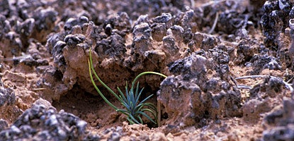
One of, if not the most, important organism that can be observed at Dead Horse Point is the cyanobacteria communities that form the biological crust that help preserve the integrity desert soils. These colonies of cyanobacteria form rigid, dark colored crust that allow plants to remain rooted in the otherwise fragile desert soils (Alejandro et. al. 2001). Not only do they act as an anchor for plants to root themselves, but they also serve as a sponge, absorbing more precipitated water than the desert soils could without their presence. Without these biological crusts, desert soils would be very susceptible to erosion from precipitation and wind-driven mechanisms.
Historical Content:
Dead Horse Point gets its name from the primary use of the point in the early 1800s as a corral for the herds of wild mustangs that Western explorers came upon during the explorations out west. These cowboys devised clever methods to trap these fast-footed animals by herding them into the narrow neck of the point and constructing simple juniper fences to corral the animals. In these corrals they were able to sort the profitable, healthy steeds from the weaker, less desirable ones. The lesser were left behind with some bands of horses ultimately dying from dehydration in the hot Utah sun with water within sight, but not within reach, approximately 2000ft below in the Colorado River.
Current Uses:
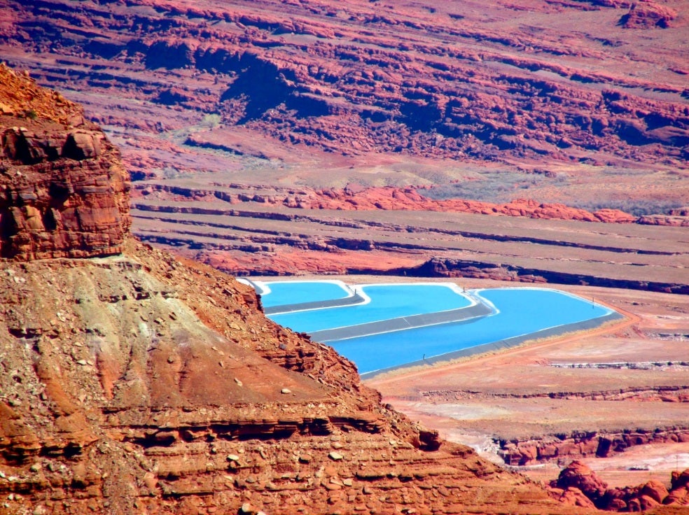
Lying below Dead Horse Point are extensive deposits of potash. Potash- the mineral potassium chloride, derived from the Pennsylvanian Paradox formation, a relict evaporite deposit from an ancient inland sea that existed 286 to 320 Million years ago. Water from the Colorado River is pumped into the formation to create slurry that is then pumped in shallow ponds left to evaporate. The remaining salt crust is harvested and is turned into fertilizer for agricultural crops.
Not only is there potash within the Paradox formation, but there are also gypsum deposits as some petroleum products (Hite, Anders, and Ging 1984). Although these are not as economically significant as the Potash deposits, they are worth noting.
Past Uses:
During the early 1940s and into the late 1950s mining companies discovered economically and nationally significant deposits of uranium in the Chinle and Paradox Formations of Dead Horse Point (Chenoweth 1996). These deposits were mined and used in the creation of weapons grade uranium during World War II and the beginning of the Cold War Era, as well as uranium used in nuclear reactors. Although significant in the post WWII and Cold War eras, these mines are no longer used today.
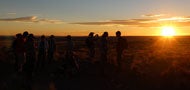
Dead Horse Point State Park was one of the most beautiful stops along the entire trip. It is one of the only points during the trip that you can get a panoramic view of the Colorado River, Canyonlands, and the La Sal Mountain range all in one shot. If you are fortunate enough to camp there, be sure to wake up early and catch the sun rising over the mountains and shedding light into the Canyon below.
References
Alejandro, L.C., Ferran, G.P., and Ulrich, N., 2001., Phylogenetic and Morphological Diversity of Cyanobacteria in Soil Desert Crust from the Colorado Plateau in Applied Environmental Microbiology. Vol. 67, no. 4, pg. 1902-1910
Chenoweth, W.L., 1996, The uranium industry in the Paradox basin, in Huffman, A.C., Jr., Lund, W.R., and Godwin, L.H., editors, Geology and resources of the Paradox basin: Utah Geological Association Publication 25, p. 95-108.
Hellmut H. Doelling and Thomas C. Chidsey, Jr., 2000, DEAD HORSE POINT STATE PARK AND VICINITY GEOLOGIC ROAD LOGS, GRAND AND SAN JUAN COUNTIES, UTAH, Geologic Road, Trail, and Lake Guides to Utah’s Parks and Monuments, 29, Utah Geological Survey
Hintze, L.F., 1993, Geologic history of Utah: Brigham Young University Geology Studies Special Publication 7, p.202
Hite, R.J., Anders, D.E., and Ging, T.G., 1984, Organic-rich source rocks of Pennsylvanian age in the Paradox basin of Utah and Colorado, in Woodward, J., Meissner, F.F., and Clayton, J.L.,
editors, Hydrocarbon source rocks of the Greater Rocky Mountain region: Rocky Mountain Association of Geologists Guidebook, p. 225-274.
Nelson, S.T., Heizler, M.T., and Davidson, J.P., 1992, New 40Ar/39Ar ages of intrusive rocks from the Henry and La Sal Mountains: Utah Geological Survey Miscellaneous Publication MP-92-2, p.24