Spatial Services is responsible for maintaining the University’s spatial data.
Systems
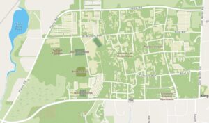
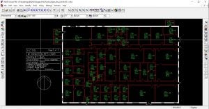
Spatial Services utilizes the Net-FM™ web-based CAFM system and the Visual-FM™ floor plan integration software from INSITE to maintain the interior space inventory data. Outdoor spatial data is maintained in the Esri suite of mapping and spatial analytics software. Spatial Services is in the early implementation stages of the University’s first Geospatial Strategy. Contact Spatial Services for a consultation regarding your department’s spatial data needs.
Data
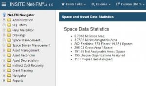
The INSITE Net-FM™ database has been identified by the University as the system of record for building-related data such as building name, street addresses, room numbers, and departments occupying a building. Accurate and timely space data serves two purposes. First, it enables the University to effectively plan for future space needs. Second, it provides the Office of the Controller with the space data required to negotiate the indirect cost recovery (ICR) rate for federal grants.
The critical data elements Spatial Services captures include unique identifiers for each University campus, building, floor, and space. Expanding on that concept, the data is augmented with square footage, department allocation, and space type or use. The space type or use is a key building block in establishing the University’s space inventory in accordance with the Postsecondary Education Facilities Inventory Classification Manual (FICM). FICM is a tool developed by the National Center for Education Statistics that guides higher education institutions in creating and maintaining a space inventory. Additionally, Spatial Services captures office occupants, principal investigator laboratory assignments, and additional space-related data deemed vital to the University’s strategic decision-making process.
Space planning

Spatial Services also plays a pivotal role in space planning by managing the University’s space request process. This includes routing the space request form, performing space audits, developing solutions to space requests, and serving as support for the University’s Space Allocation Committee (SAC). We also support space data and report requests for all University community members including a basic data dump from the database in various spreadsheet formats, more complex spreadsheet and pivot table reports utilizing live connections to the database for ease of refreshing the data, or data visualizations, maps, and dashboards created in ArcGIS or Microsoft Power BI.
University Space Planning