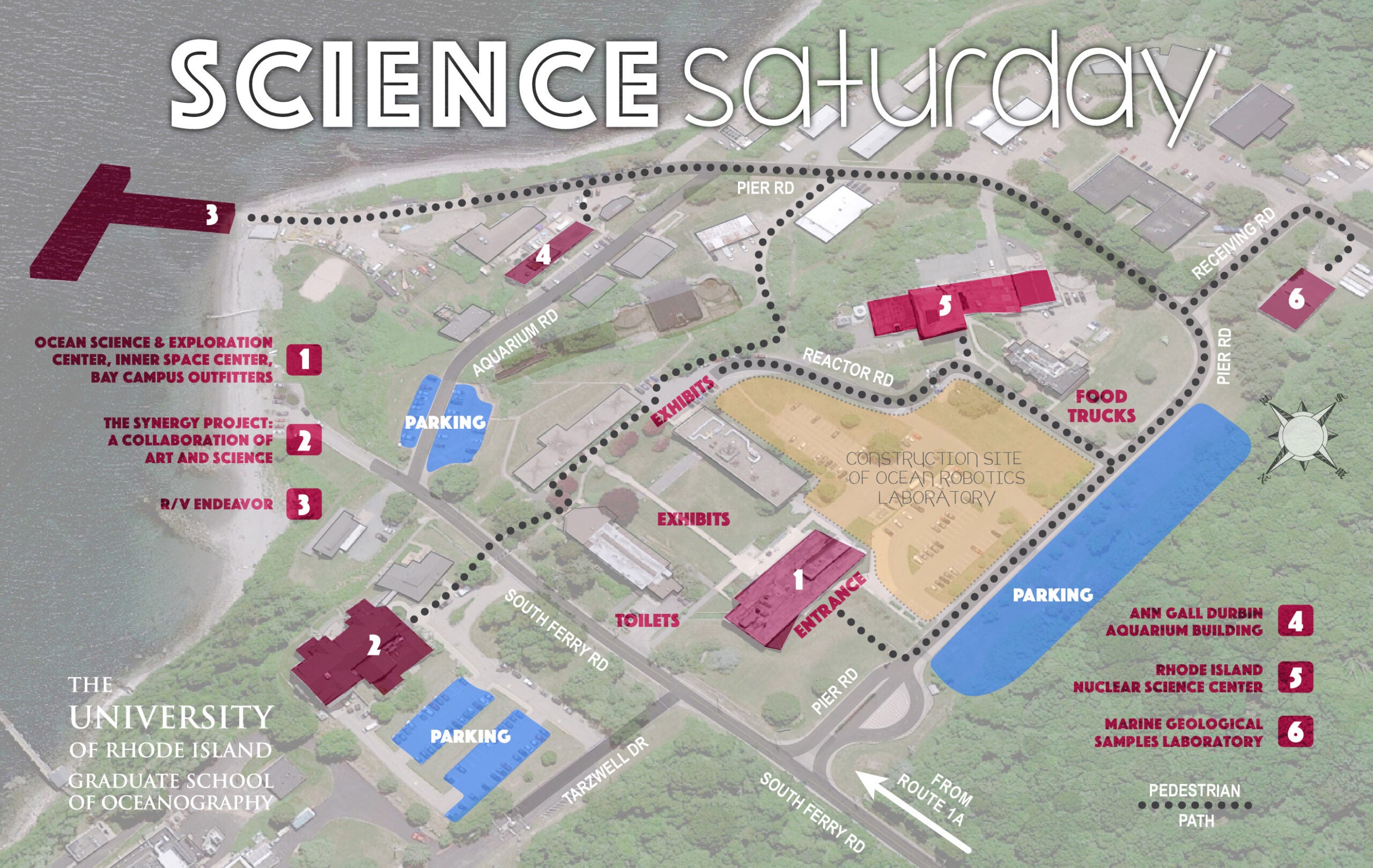
Directions and Campus Map
University of Rhode Island
Narragansett Bay Campus
215 South Ferry Road
Narragansett, RI 02882
By Car
For GPS, use street address of 215 South Ferry Rd, Narragansett, RI, 02882 or Lat. 41.39834, Long. -71.489301 .
From the West
Via Rt. 1. Interstate 95N to Exit 92 in Conn. Right turn after leaving expressway, then about 1.5 mi. on Conn. 2 to 78. Take Rt. 78E (a barrier divides the roadway) 4 mi. to Rt. 1N in Westerly, R.I. Go left on Rt. 1N for about 27 mi. to intersection of Rts. 1 and 138. Make a right onto Bridgetown Rd. Continue to next traffic signal (intersection of Bridgetown Road and Scenic 1A). Cross intersection onto South Ferry Rd. Continue past South Ferry Industrial Park on the right and South Ferry Church on the left. Entrance to campus is on the right. Via Rt. 138. Interstate 95N to exit 3A in R.I. (Kingston exit). Turn right off exit ramp onto Rt. 138E (Kingstown Rd.). Continue on 138 (passing the University’s Kingston Campus on the left) to Rt. 1 and cross the junction onto Bridgetown Rd. Continue on Bridgetown Rd. to South Ferry Rd. Continue past South Ferry Industrial Park on the right and South Ferry Church on the left. Entrance to campus is on the right.
From the North
Interstate 95S toward N.Y. and Narragansett. (From T.F. Green Airport, follow the Airport Connector signs to join 95S at exit 13.) Continue on 95S to Exit 9 and exit in left lane off highway onto Rt. 4S. Continue to Rt. 1 and the junction of Rt. 138W. Take a left at the tower onto Bridgetown Rd. Continue to South Ferry Rd. Continue past South Ferry Industrial Park on the right and South Ferry Church on the left. Entrance to campus is on the right.
From the East
Rt. 195 to 24S to 138W. Cross Newport and Jamestown Bridges. Take the first exit after the bridge onto Rt. 1A toward Narragansett. Continue south to the first traffic signal and make a left onto South Ferry Rd. Continue past South Ferry Industrial Park on the right and South Ferry Church on the left. Entrance to campus is on the right.
By Bus
Two Rhode Island Public Transportation Authority (RIPTA) bus lines serve the Bay Campus: the #64 line and the #14 line. Also, the Bay Campus is within the zone served by RIPTA’s Flex On Demand service. For details on bus routes and schedules visit RIPTA.com.
- RIPTA bus route #64 (There is a bus stop at Narragansett Bay Campus, across from the OSEC building parking lot (Lot C).
- RIPTA bus route #14 (Use the bus stop at the corner of Route 1A and South Ferry Road. Head east.)
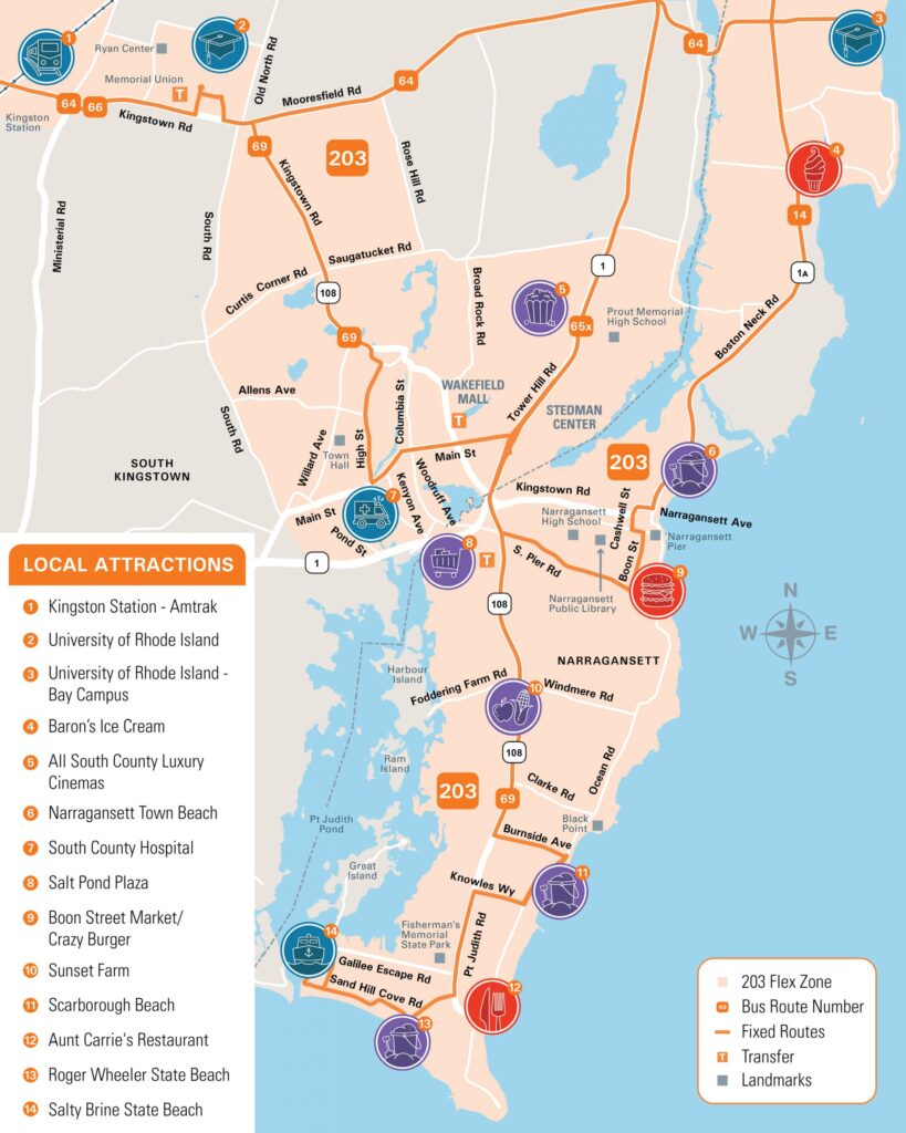
- RIPTA’s Flex On Demand is available in Narragansett, South Kingstown and Kingston. Travel within the zone or transfer to a RIPTA bus! Similar to other on-demand rideshare services, Flex On Demand allows passengers to use a smartphone app to request a ride to and from anywhere they wish to travel within the Flex Zone. Following a ride request, the app will provide an estimated pick-up time, track rides in real-time, and provide an alert upon arrival. Download the app & view the map below.
Saturday Stop Times
RIPTA Flex Zone Map
Narragansett to Providence
- 11:34
- 2:35
- 5:38
Providence to Narragansett
- 10:35
- 1:34
- 4:33
Kingston to Newport
- ~11:10
- ~1:23
- ~3:38
- ~5:48
Newport to Kingston
- ~10:30
- ~12:40
- ~2:55
- ~5:07
By Rail
The Kingston Railroad Station (AMTRAK code KIN) is located at 1 Railroad Ave, West Kingston, RI 02892. From the railroad station, head east on Rte. 138 (passing the University’s Kingston Campus on the left) to Rt. 1 and cross the junction onto Bridgetown Rd. Continue on Bridgetown Rd. to South Ferry Rd. Continue past South Ferry Industrial Park on the right and South Ferry Church on the left. Entrance to campus is on the right. Total distance is about 8 miles.