
KINGSTON, R.I. – August 26, 2026 – For CELS Summer Research Fellows Carissa Sherman and Jaired Flanagan ’26, this summer offered an opportunity to use geographic information systems (GIS), hydrologic modeling, and environmental data to examine two interconnected challenges facing Rhode Island: flooding and water pollution.
Working with Professor Soni Pradhanang, the students investigated how water moves through Rhode Island’s watersheds and how communities can better manage stormwater before it reaches rivers and Narragansett Bay. Pradhanang, a professor of water resources and water quality, studies how sediments and nutrients move through watersheds, with a focus on the effects of land use and climate change.
Tracking pollution from watersheds to Narragansett Bay
Sherman’s project examined how pollutants move through watersheds and into Narragansett Bay.
A cell and molecular biology major focused on the biochemistry track, Sherman worked with Pradhanang last summer on groundwater mapping following the removal of the Potter Hill Dam. This summer, she used GIS and the EPA’s Pollution Load Estimation Tool to develop a framework for estimating nonpoint-source pollution across watersheds in Rhode Island, Connecticut, and Massachusetts.
Geubrina Farjria, Ph.D candidate working with Dr. Pradhanang, worked closely with Sherman throughout the fellowship, helping with the development and analysis of the project.
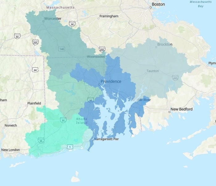
Sherman’s goal was to identify which subwatersheds contribute the greatest loads of nitrogen, phosphorus, and sediment — and where best management practices could be most effective at reducing those pollutants before they reach waterways.
She divided the region into six major subbasins, including the Blackstone, Taunton, and Pawtuxet watersheds and the southern coastal ponds. By combining land-use, precipitation, agricultural, and septic data, the model can estimate pollutant loads and the potential reductions associated with practices such as riparian buffers, tree plantings and other stormwater controls.
For the Southwest Coastal Ponds subbasin, for example, Sherman’s model can estimate baseline nitrogen, phosphorus, and sediment loads in tons and pounds per year — then calculate how much of that load a specific intervention, like a riparian buffer or streamside tree planting, would prevent from ever reaching the water.
Mapping how water moves through Providence
While Sherman traced pollution across the wider region, Flanagan zoomed in on a single, flood-prone site: Roger Williams Park in Providence.
Flanagan, currently a student in URI’s Master of Environmental Science and Management program, looked at flooding in and around the park, examining how changes in land cover have affected the movement and retention of stormwater. He came to the project with firsthand experience; he’d previously worked at the park as a water resource monitoring technician for the Stormwater Innovation Center.
Flanagan’s project is part of his graduate mentor Pratik Singh Thakuri’s larger research on flooding and stormwater. Thakuri, a Ph.D. student working with Dr. Pradhanang, worked closely with Flanagan throughout the fellowship, providing guidance on the modeling and analysis. Both Flanagan and Thakuri are funded through the NSF EPSCoR FEC grant, led by Dr. Pradhanang, titled “Equitable NAture-based ClimaTe Solutions (ENACTS).”
Using publicly available datasets and hydraulic modeling software, Flanagan modeled the response of the park’s watershed to a March 2010 storm that brought about 8.8 inches of rain. He compared scenarios using land-cover data from 2001 and 2021.
His results showed that the amount of water was not substantially different between the two scenarios. Instead, the changes were in how quickly water moved and where it accumulated. More impervious surface in 2021 allowed water to move more quickly from developed areas, concentrating it in low-lying areas of the park and surrounding neighborhoods. Flanagan found that approximately 98% of peak flood discharge was generated locally within the watershed, while only about 1.4% came from Mashapaug Pond.
That question is one the Stormwater Innovation Center is already working to answer. The organization, led in part by associate director Molly Welsh ’13, works to improve stormwater management and water quality throughout New England, and has installed more than 35 green stormwater control measures throughout Roger Williams Park to capture and filter runoff.
The center monitors their performance with URI students, researchers, and community members — and Flanagan’s model offers a way to help, showing not just how water moves through the park’s watershed, but where existing infrastructure is best positioned to intervene.
Together, the projects demonstrate how student research can connect data-driven environmental science with practical solutions for communities like those along Narragansett Bay.