URI programs secure state funding for CHAMP, StormTools, and MyCoast, to continue providing critical services for Rhode Island
July 21, 2025
Rhode Island legislators have endorsed a powerful complement of tools developed and housed at the University of Rhode Island so they can continue to benefit the state coastline and residents, approving $200,000 in the 2026 fiscal year budget. Legislators and researchers say that support to keep URI’s critical CHAMP, STORMTOOLS, and MyCoast programs going demonstrates that URI, and Rhode Island, will continue to lead in coastal safety analysis, early warnings, and resilience.
Developed by URI’s Coastal Resources Center, Rhode Island Sea Grant, the Graduate School of Oceanography, the Environmental Data Center, and the departments of Marine Affairs and Ocean Engineering, these tools were created to help Rhode Island’s emergency managers, partner communities, state agencies, and military better plan for and respond to storms and flooding.
“We’ve been working together on these projects for 10 years,” says Austin Becker, chair of URI’s Department of Marine Affairs and director of URI’s graduate certificate in Coastal Resilience, “and the collaboration has been truly wonderful.”
Funding for research and development came from the Department of Homeland Security, the Federal Emergency Management Agency, Department of Defense, and numerous other sources. In the years since, URI has dedicated significant expertise and resources to develop the powerful suite of tools, which play key roles in addressing coastal storm risks.
The Rhode Island state funding affirms support in the Ocean State for technology and tools that prepare for weather impact in advance.
“This is a huge win,” says Becker. “This will allow us to keep these tools in operation, supporting the climate resilience needs of Rhode Island. It’s gratifying to see the state recognize the value of this work to municipalities and agencies from the Coastal Resources Management Council (CRMC) and Rhode Island Emergency Management Agency to the Department of Environmental Management and Department of Health.”
As federal funding priorities changed, Rhode Island pivoted to maintain support for these critical emergency preparation and management tools, as support from community users demonstrated the value of the tools.
The initial bill was sponsored by Rhode Island Rep. Terri Cortvriend (Middletown, Portsmouth), who first came to Rhode Island as a boat captain. She founded a marine plumbing firm here and is familiar with coastal issues as a member of the state’s marine trade association, but says she advocated for the provision out of concern over seeing Rhode Island lose funding for these critical decision support tools.
Introducing the measure, Cortvriend asked her peers to join her in supporting Rhode Island’s homegrown coastal resilience technologies. “As we face increasing risks to our population due to more frequent and severe storms,” she said, “it is imperative that we equip our decision-makers and emergency managers with the tools necessary to mitigate impacts, enhance recovery, and reduce both human suffering and economic losses. These tools provide crucial data and predictions for emergency management, resilience planning, and community engagement across our state.”
Stephen McCandless M.S. ’21, GIS coordinator for the town of Charlestown, said the tools are essential for emergency management, planning, and coastal policy work in Rhode Island.
“These tools have proven indispensable in our ability to manage and prepare for coastal hazards,” he said. “We rely on them regularly in our operations.”
Save The Bay’s Jed Thorp also wrote in support, saying the organization’s mission to protect and improve Narragansett Bay depends on government partners who can deploy such tools to make informed decisions based on sound science.
With this investment from the state, URI will continue to offer these three powerful tools to meet Rhode Island’s critical resilience planning and emergency management needs:
RI-CHAMP (Coastal Hazards Analysis, Modeling, and Prediction)
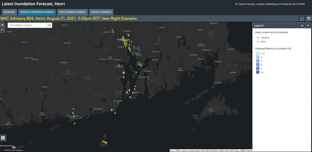
RI-CHAMP lets emergency responders predict damage to vital infrastructure in real time. The modeling system offers early warnings of coastal storm impacts, giving agencies critical time to prepare for hurricanes and nor’easters and can provide storm simulations that help officials plan for the future. The program can create detailed flood models, examining impact to infrastructure, such as electrical transformers and backup generators, or the potential impact to hazardous waste in ports during a hurricane. CHAMP is used by the Rhode Island Department of Environmental Management and Emergency Management Agency and has also been utilized by the Department of Health and the Naval Station in Newport. CHAMP has also been utilized by Connecticut and by the Massachusetts Coast Guard to examine storm impact in those regions.
RI-CHAMP computations rely on the URI High Performance Computing UNITY cluster, which has proven indispensable for real-time storm forecasting. The IT Research Computing team led by Gaurav Khanna, director of URI’s Institute for AI and Computational Research, has worked closely with RI-CHAMP scientists to deliver valuable results on time using computational resources built and managed in partnership with the University of Massachusetts.
“CHAMP delivers accurate, high-resolution predictions of storm surge, wind, and wave impacts,” says Isaac Ginis in URI’s Graduate School of Oceanography. “Its capabilities have proven essential to emergency management agencies as they confront increasingly intense storm events.”
While hurricanes often capture the most attention, he notes that nor’easters—cold-season storms known for their high winds and heavy surf—pose a growing threat in New England, straining infrastructure.
“With this state investment, CHAMP will remain a critical tool for real-time emergency response and long-term coastal planning,” he says, “helping Rhode Island communities better prepare for future storms.”
RI-CHAMP is currently expanding its capabilities to include 24/7 real-time monitoring of flood and meteorological data in a hyperlocal network of smart flood, wind, and rain sensors at key infrastructure and transportation routes, enhancing its ability to generate accurate, timely alerts.
STORMTOOLS
STORMTOOLS provides up-to-date predictions on flooding that could affect commercial and residential sites across the state, providing flood predictions essential for long-term planning. Development of the tool began in 2014 with creation of flooding maps for Washington County and eventually the entire state. A mobile phone app was also developed to allow access to risk estimates for individual structures. In 2020, a STORMTOOLS Hub was established at URI to allow access to state agencies, town planning departments, consulting firms, and citizens.
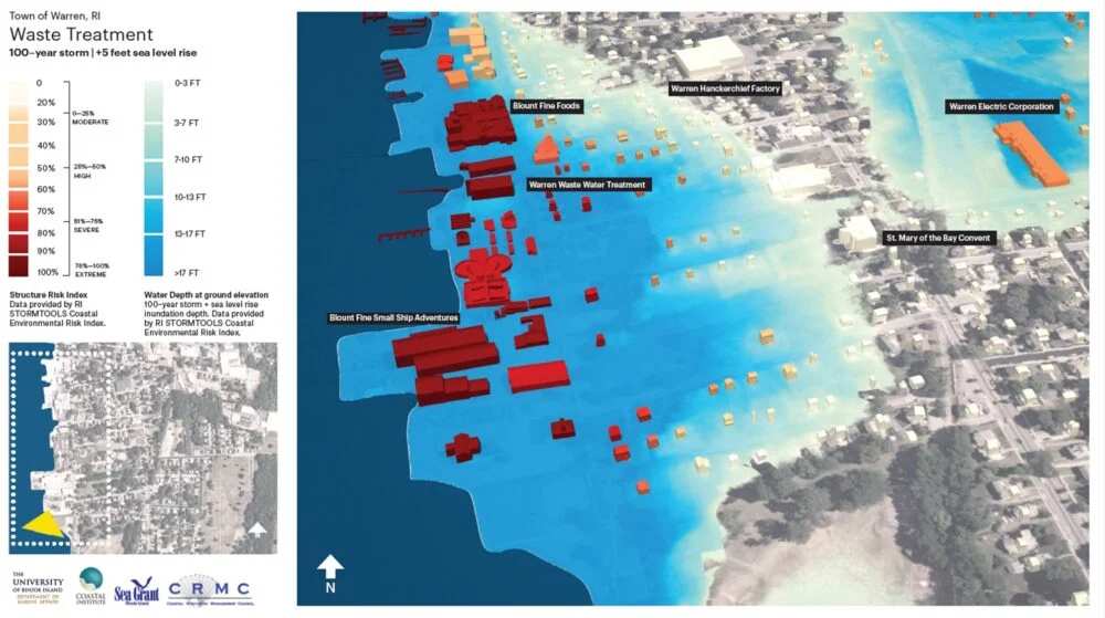
STORMTOOLS is also embedded in the CRMC coastal hazard permitting system and used routinely to understand the risks of flooding with consideration for sea level rise. The program is now expanding its reach to include inland areas subject to riverine flooding. It has also been recently extended to allow damage from hurricane winds.
“STORMTOOLS is one of the first tools in the nation to provide access to estimates of storm flooding that explicitly include the impact of climate change—sea level rise and enhanced precipitation,” says Malcolm Spaulding, professor emeritus of ocean engineering.
STORMTOOLS is widely used by state agencies for planning and risk assessment, with more than 10,000 users per year. The state has used the program for analysis of vulnerable roadways and other infrastructure. The I-195 Commission relied on its data in increasing the elevation of the Providence River Pedestrian Bridge.
MyCoast: Rhode Island
MyCoast: Rhode Island is a portal used to collect and analyze crowd-sourced photos of flooding and erosion across the Ocean State. The information collected captures the impact of flood hazards today and illustrates possible future conditions with increased storm activity.
This tool not only serves Rhode Islanders, it lets them contribute to data-driven science. According to Casey Tremper, coastal resilience specialist with Rhode Island Sea Grant and Coastal Resources Center, MyCoast has obtained more than 5,200 pictures from 1,700 volunteer monitors since its inception in 2014.
“The tools that URI has developed for monitoring, modeling, and predicting coastal hazards are vital to how Rhode Island prepares for and mitigates future impacts,” she says. Efforts are underway to expand the tool’s capacity to also monitor inland flooding.
While MyCoast is a tool also used in other states, CHAMP and STORMTOOLS are unique to Rhode Island.
“Nobody has programs like this,” says Becker. “No one else is doing this kind of interdisciplinary, applied work focused on meeting the unique needs of end users. We’ve co-developed this technology in close partnership with Rhode Island’s emergency management and resilience planning communities.
“Rhode Island and URI are innovators in this space. We need these kinds of programs to make informed investments and emergency management decisions. This funding is a testament to what URI as a land- and sea-grant university does for the state.”