By Lauren Thacker
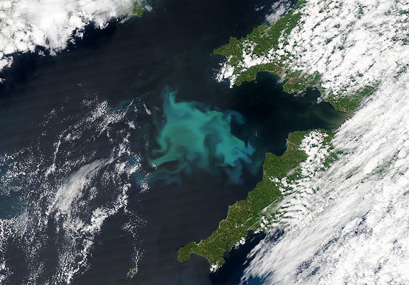
In the ocean, unicellular phytoplankton are primary producers—they synthesize their own energy and form the base of the aquatic food web. These tiny organisms are integral to carbon exchange and their health, distribution, and abundance are key indicators of ecosystem change.
In the vast ocean, microscopic phytoplankton have an outsized role. That is why observing and analyzing them is an important goal for PACE, one of NASA’s latest satellites.
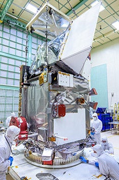
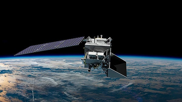
The PACE satellite, or Plankton, Aerosol, Cloud, ocean Ecosystem mission, launched on February 8, 2024 from Cape Canaveral with Paula Bontempi, Ph.D. ’01, dean of the Graduate School of Oceanography, looking on. The satellite, with a planned orbit of at least three years, will capture and transmit data about the presence of phytoplankton, as well as atmospheric aerosols, cloud properties, and air quality at local, regional, and global scales.
PACE allows us to explore our planet in the temporal dimension. This is similar to if you wear a FitBit to track your steps.Paula Bontempi, Ph.D. ’01
Contributors to the PACE mission form a tight-knit community, many of whom are alumni of URI’s Graduate School of Oceanography. From Bontempi, who was part of early PACE feasibility studies during her tenure at NASA, to the field scientists validating satellite data, GSO grads have contributed at every step of the way.
Scott Freeman, M.S. ’01, is part of a NASA team collecting in-situ data, alongside fellow GSO grad Joaquin Chaves, M.S. ’97, Ph.D. ’04. Freeman lauds the collaborative nature of the ocean science community and calls the team contributing to PACE “the best group of people I’ve ever worked with.”
Many of these connections were established well before PACE and, in fact, stem from a legendary figure at GSO. Colleen Mouw M.S. ’03, Ph.D. ’09, who will be working on satellite data validation, recognizes the impact of James Yoder, M.S. ’74, Ph.D. ’79, emeritus professor of oceanography, and former NASA program officer.
“He was at NASA when the first types of these Earth-observing satellites were launched,” she says. “If you look at the names of the GSO alumni who are part of PACE, Jim Yoder trained almost all of them. He is the linchpin of the research on optical and ocean color remote sensing at GSO.”
Jim Sullivan, M.S. ’93, Ph.D. ’00, part of the team that developed satellite instrumentation, calls PACE “a labor of love,” adding that “it’s a small community and a lot of the people can trace their work back to the Graduate School of Oceanography. GSO played a pretty big part in the satellite going up.”
It’s a small community and a lot of the people can trace their work back to the Graduate School of Oceanography. GSO played a pretty big part in the satellite going up.Jim Sullivan, M.S. ’93, Ph.D. ’00
Countdown to Launch
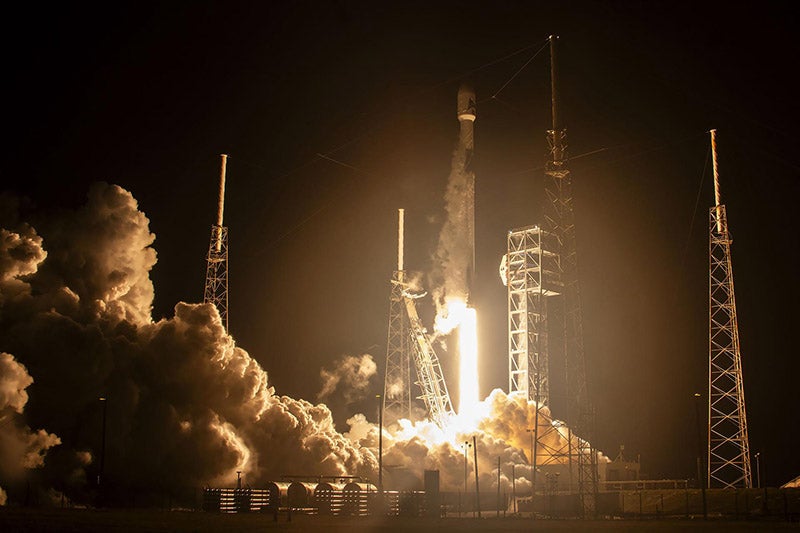
rocket, lifts off from Space Launch Complex 40.
During her 18-year career at NASA, including a stint as acting deputy director of the Earth science division, Bontempi advocated for the PACE mission, arguing that climate change and its effects on our oceans will require large-scale data in order to create interventions
Many things about the Earth and ocean remain unknown and others are changing fast. One of the biggest unknowns is direct atmosphere radiative forcing (the balance of energy, via radiation, that enters and exits the Earth’s atmosphere) and the concentration of aerosols in the troposphere and stratosphere. These aerosols contribute to poor air quality that can be devastating for people with certain health conditions or in polluted environments. In recent years, warming oceans have contributed to changes in the distribution and availability of marine life such as lobster and haddock, as well as harmful algal blooms that impact recreation, tourism, and public health.
“PACE will allow us to explore our planet in the temporal dimension,” Bontempi explains. “This is similar to if you wear a FitBit to track your steps or get your blood pressure checked annually. You can track your health over time and determine if you need an intervention and if so, what kind. With PACE, we can do the same thing for the ecology of the planet.”
Sullivan, executive director of Florida Atlantic University’s Harbor Branch Oceanographic Institute, was part of the team that developed technology for the satellite. He joined the first PACE science team in the early 2010s and recalls that participants had different ideas and priorities regarding what the satellite should measure and how.
“That’s why you have a science team,” he says. “You need different members of the community and their opinions. We’d have conversations like, ‘Do we want hyperspectral absorption sensors on the satellite? Do we want polarimetry?’ Everyone on the team contributed in some way towards the design of the satellite that’s up there now.”
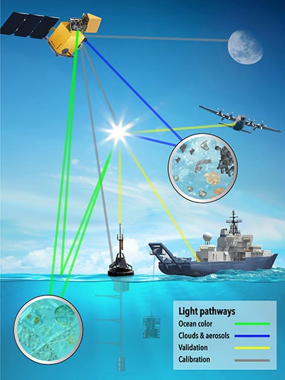
Sullivan helped to design and calibrate instrumentation to measure the absorption and scattering of light in the water, and ultimately, ocean color. Because biological materials have unique spectral signatures, this measurement can give scientists information about biomass in the water—where algae is, where phytoplankton is, how much in the water is living or dead, and more.
“Light has to travel through the atmosphere before it reaches the satellite,” he says. “Our instruments measure absorption and scattering right on the ocean and we developed techniques that ensure the satellite’s measurements, which happen at a much larger scale, are accurate.”
In addition to measuring absorption and scattering at an unprecedented scale, PACE is NASA’s first hyperspectral satellite: it is equipped with instruments that measure over 100 spectral bands, while previous satellites could capture only six to eight.
Each mission improves technology and increases discovery. Yoder is eager to see what PACE yields, calling it, “the next big thing for the satellite ocean color world.”
Bontempi was able to join former NASA colleagues at the launch, an experience she describes as “amazing, nerve-wracking, horrifying and joyful.”
“This was nearly 20 years of my life; I couldn’t let it go into space without standing next to it. Watching the launch with my own eyes was incredible,” she says. “But even after launch, there are more steps before you can breathe a sigh of relief.”
Before a launch can be fully counted as a success, the solar panels must unfurl and the spacecraft must orient itself toward the sun. The satellite has enough power to run for a limited period of time and then depends on solar energy. There have been cases of satellites failing to orient and becoming inoperable, bringing years of hard work and collaboration to an abrupt and unsatisfying end.
“About an hour after launch, flight control gave the all-clear that she was power-positive,” Bontempi recalls. “My son was with me and he said, ‘Mom, you did it!’ I said, ‘No, we did it!’”
Data, Data Everywhere
The PACE satellite will provide near-daily information about the whole of the Earth’s oceans.
“If we had to do this measuring with boats and in-ocean sensors, it would take us years,” Sullivan says. “The satellite does this every day. Now that it is launched, scientists will go out and take high resolution measurements to validate what the satellite tells us. With this validation, we can extrapolate and ensure we are getting accurate data about places we are unable to go.”
Mouw, Chaves, Freeman, and Kimberly Hyde, Ph.D. ’06, are just some of the people collecting and validating data.
Freeman and Chaves, scientists at NASA, have been working on the PACE mission for over six years, collecting biogeochemical and optical data to develop algorithms for the satellite’s instrumentation and data collection. Now that the satellite has launched, they are part of a field data team. In spring 2024, they worked aboard the research vessel Thomas G. Thompson, owned by the U.S. Navy Office of Naval Research and operated by the School of Oceanography at the University of Washington.
The first trip, to the Bay of Bengal, will be followed by a circumnavigation of Florida and a cruise off the coast of Santa Barbara, Calif. During development of PACE’s capabilities and now, the team looks for data collection opportunities wherever they can find them.
“In previous years, we’ve gone from the Southern Ocean to the Arctic,” says Freeman. “We try to collect a lot of data where there’s not much that has been collected before. So, we always look for ships of opportunity. If we find a research vessel that is going to an area where we’d like to collect data, we try to make the need known and usually get an invitation.”
In her role as operations research analyst at the National Oceanic and Atmospheric Administration (NOAA), Hyde facilitates some of these connections.
“NOAA has ships going out on routine monitoring cruises,” she says. “These surveys are a good opportunity to collect coastal ocean data the PACE teams need. Colleen [Mouw] has the instruments and we have ships, so this is an excellent opportunity to collect PACE validation data in highly productive, yet optically complex waters. What we will learn from PACE has the potential to play a role in NOAA’s ecosystem-based approaches to management.”
Mouw, a URI professor of oceanography and associate dean for diversity and academic affairs at the Graduate School, will go on her first research cruise in winter 2025. This is one of several ecosystem monitoring cruises that travel the northeast continental shelf from Cape Hatteras to the Gulf of Maine. She, her research staff, and graduate students involved in the project will be taking continuous measurements above the water, with additional testing during research station stops.
Mouw explains, “We are going to be measuring above water radiometry, water column profile radiometry, absorption, scattering, fluorescence, pigments, and phytoplankton composition, using tools and tests like flow cytometry and the Imaging FlowCytobot. We’re going to be out on the ocean a lot in the next three years as we get rolling with this project.”
We’re going to be out on the ocean a lot in the next three years as we get rolling with this project.Colleen Mouw M.S. ’03, Ph.D. ’09
Answering Questions, Known and Unknown
Bontempi says, “NASA has had many Earth observing satellites in its history and PACE adds to that knowledge. We can pull this information together and detail what we know about our planet and what remains unknown. The work continues and future missions will be able to provide observations that answer some of those unknowns.”
Among the many areas that GSO alums hope to gain insights are the detection of harmful algal blooms; the development of new algorithms for analyzing phytoplankton composition in varied environments, such as coastal waters or open oceans; how carbon cycles from the upper ocean to the deep ocean; and fisheries management.
For example, observations of phytoplankton productivity and composition can improve estimates of food availability in the ocean and support sustainable fisheries management. In addition, satellite data can indicate near real-time changes in water masses, which could be used in dynamic ocean management tools such as warnings about aggregations of protected species near shipping lanes or fishing grounds.
It’s real world applications,” says Hyde. “There are potential applications for PACE data, but it will take time before we can implement it in management.”
A lot of people, will be able to get their hands on the data. NASA has always made their Earth observing satellite data publicly available. But, as Bontempi points out, available doesn’t always mean accessible and equitable. If the data is presented without context or contained on a difficult-to-navigate website, people outside of the agency may not realistically be able to use it. In recent years, NASA has spent time thinking about how to make data more accessible for people in the general public, as well as for members of operational agencies like the Environmental Protection Agency and NOAA, something Bontempi calls “an investment and a tremendous step forward.”
The more people who can access PACE’s wealth of data, the better. Sullivan says that the history of satellites tells us that PACE will provide answers that right now, no one even knows to look for.
“People push technology and then suddenly realize that new things are possible,” he says. “I am really excited to see what scientists in the future will do with all this data and what incredible things they will discover.”
Other contributors to the PACE mission include: Timothy Moore, M.S. ’96, and Jason Graff, Ph.D. ’10, who work on algorithm development and data validation efforts; Kari St. Laurent, Ph.D.’14, the product portfolio manager of PACE products for NOAA; Chris Melrose, Ph.D. ’05, who works on data validation and developing new PACE products for NOAA Fisheries; Malcolm McFarland, Ph.D. ’00, and Mike Twardowski, Ph.D. ’98, who developed instrumentation and science for field optical validation.