URI oceanographer to study air-sea exchange of heat, carbon in the Gulf Stream
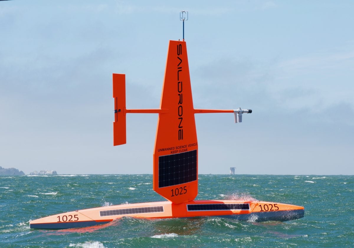
A cutting-edge scientific drone was launched Wednesday morning, Jan. 3o, from Newport Harbor to assist with a University of Rhode Island study. While it may resemble a seven-meter-long sailboat, the unmanned surface vehicle will journey without a single crewmember on an important mission to better understand the role that the ocean plays in the Earth’s climate.
Last year, URI Graduate School of Oceanography Assistant Professor Jaime Palter received a Saildrone Award, which provides 30 days of data collection using one of the Alameda, California company’s ocean drones. On Wednesday, the wind- and solar-powered drone left Newport Shipyard to gather data for Palter’s research in the Gulf Stream.
Western boundary currents – fast-flowing, warm currents like the Gulf Stream that flow along the western sides of the world’s ocean basins – are challenging environments for scientific observation. Understanding how these currents work is fundamental to understanding climate, so Palter will use the Saildrone to collect data not easily gathered by traditional means like research vessels and buoys. Specifically, Palter’s mission is to better understand the transfer of heat between the Gulf Stream’s waters and the atmosphere, as well as how much carbon is absorbed by the current.
“The Gulf Stream is only a few hundred miles from Rhode Island’s shore, but even on cold winter days it has a surface temperature over 70 degrees Fahrenheit,” said Palter. “Storms moving west off of North America gain energy as they suck heat out of the current. These storms also prime the ocean to absorb carbon dioxide. Making ship-based observations under such stormy conditions has always been extraordinarily difficult, yet these are precisely the conditions we need to observe to understand the ocean carbon sink and its role in weather. The Saildrone will enable us to make these needed observations where they have been lacking in the past.”
The Saildrone will be equipped with sensors to help study atmospheric and oceanographic data, including a new sensor – developed by the National Oceanic and Atmospheric Administration and funded for this mission by the National Science Foundation – to measure the exchange of carbon dioxide across the ocean’s surface
“NOAA designed an ingenious, self-calibrating sensor that has been incredibly successful at measuring the seawater concentration of carbon dioxide from the hull of the Saildrone,” said Palter. “Another sensor on top of the drone measures carbon dioxide in the atmosphere. Knowing the difference between the atmospheric and oceanic concentrations, along with the wind speed, also measured aboard the Saildrone, allows us to calculate the exchange of this gas between the ocean and atmosphere.”
Saildrone technology provides scientists with safe access to remote areas or dangerous conditions, and the 30 days of free data collection provided by the company for Palter’s mission is equivalent to an estimated $1 million worth of research ship time. However, the technology doesn’t replace the value of ocean-going research vessels, instead it is intended to fill in data collection gaps and can sample remote regions in any weather. As the robotic platform is relatively new, Palter and her collaborators will be aboard the R/V Endeavor following closely behind the drone during the last week of its mission, collecting the same measurements to verify the data that the drone gathers.
Saildrone technology is already being used by scientists across the globe, but the oceans remain largely unexplored and under sampled.
“Saildrone’s long-term vision is to use autonomy to collect oceanic and atmospheric observations over extensive areas and extended periods of time,” said Sebastien de Halleux, chief operating officer at Saildrone. “We are excited to partner with the University of Rhode Island’s Graduate School of Oceanography on the launch of this important Atlantic mission and further the understanding of the critical role of the Gulf Stream.”
Palter’s Gulf Stream mission is the first step toward a larger goal: using the new carbon dioxide sensor to collect measurements via Saildrone in the under sampled Western Boundary Currents in the South Atlantic and Pacific. Long considered carbon sinks – areas that can absorb large quantities of carbon dioxide – Palter says that these currents have potentially massive economic value, but our understanding of them remains poor.
“Existing carbon budgets demand a Southern Hemisphere sink for human-caused carbon dioxide emissions of approximately 1 billion tons per year, more than 10 percent of global emissions,” said Palter. “Considering that carbon taxes between $10 and $100 per ton have been implemented in some countries, this sink has an economic value in the tens to hundreds of billions of dollars per year. Yet we have major gaps in our understanding of where and how the carbon is absorbed, and how vulnerable these regions may be to future changes in ocean circulation and warming.”