One morning per week, year round, the GSO Fish Trawl Survey samples two locations:
| Site | Location | Coordinates | Depth Range at Low Tide (North to South Along Tow Line) | Bottom Substrate |
|---|---|---|---|---|
| Fox Island | Adjacent to Quonset Point and Wickford | 41°34.5′ N, 71°24.3′ W | 20 feet (6.1 meters) to 26 feet (7.9 meters) | Soft mud and shell debris |
| Whale Rock | Mouth of West Passage | 41°26.3′ N, 71°25.4′ W | 65 feet (19.8 meters) to 85 feet (25.9 meters) | Coarse mud/fine sand |
Collection
Fish and invertebrates are collected during a single 30 minute tow at each station. The towing speed is 2 knots. The net has a tickler chain footrope and floats attached to the headrope.
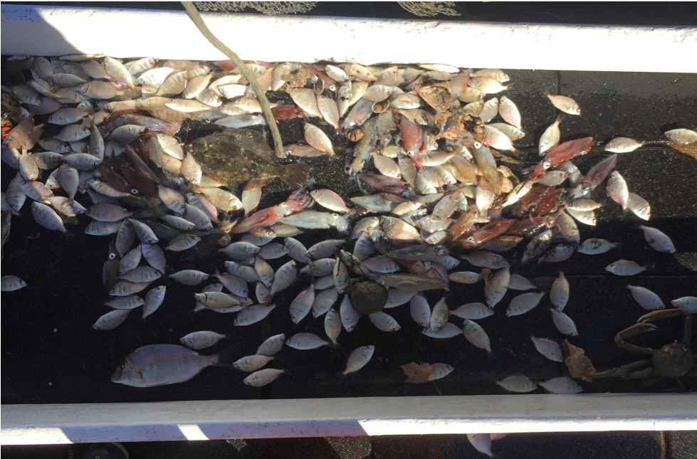
The trawl net is emptied into the water-filled checker. The checker is sometimes filled with water to preserve specimens alive. Usually, captured fish and invertebrates are sorted directly on the deck and then transferred to water-filled barrels.
Gear Dimensions:
| Gear type | Dimensions |
|---|---|
| Net type | 2-seam with bag |
| Length of headrope | 39 feet (11.9 meters) |
| Otter boards | steel, 24 inches tall, 48 inches long (61 centimeters by 1.24 meters) |
| Distance from otter boards to net | 60 feet (18.3 meters) |
| Mesh size: net | 3 inches (7.6 centimeters) |
| Mesh size: codend | 2 inches (5.1 centimeters) |
| Distance between otter boards while fishing | 52 feet (15.8 meters) at Fox Island 64.5 feet (19.7 meters) at Whale Rock |
Measurement
The number (since 1959) and live weight (since 1994) of each species captured is recorded. Since 1986, the length of winter flounder (Pseudopleuronectes americanus) has been measured to the nearest centimeter, and sex determined by holding each winter flounder up to the light to examine the size, shape, and/or color of the gonads. Typically, fish and invertebrates captured during the GSO Fish Trawl Survey are released unharmed.


Surface and bottom temperature have been collected since 1959 at each site using a bucket or Niskin bottle to collect water from the surface or bottom, respectively, and a standard thermometer to measure temperature. More recently (intermittent during 2006 and resuming full time in October, 2007), temperature, salinity, and dissolved oxygen have been measured at the surface and bottom at both sites using a YSI® (Model 6920 V2) multi-parameter water quality sonde outfitted with depth, conductivity, temperature, and ROX® optical dissolved oxygen probes. Temperature, salinity, and dissolved oxygen are measured at one meter intervals throughout the water column at Fox Island in order to identify the depth of low oxygen conditions that may develop near the bottom.
Data
Graduate School of Oceanography Fish Trawl Survey data since 1959 are preserved in hard copy (both original data sheets and revised final copies) in the laboratory of Jeremy Collie on the Graduate School of Oceanography campus in Narragansett, Rhode Island. Fish Trawl Survey data are also maintained in electronic format using Microsoft® Access®.
Water quality data (as well as salinity and dissolved oxygen data since 2007) are available on the Data page of this website. Graduate School of Oceanography Fish Trawl Survey data is available upon request by contacting the Graduate School of Oceanography Fish Trawl Survey graduate student assistant listed on the Contact page of this website.