Home
Home Browse
 Close
Close Events
 Maps
Maps Email
Email Brightspace
 eCampus


Seeing Green
Landscape architecture students are imagining better versions of the towns and schools around them
When Rhode Islander Rowland G. Hazard gazed at a breathtakingly beautiful stretch of his land holdings in South Kingstown back in 1819, he was drawn in recollection to his stay in the lovely Dalarna region of central Sweden, a place of verdant forests, fish-filled lakes, and rolling orchards. Hazard named his pastoral acreage “Dalecarlia.”
If he could only see Dale Carlia Corners today.
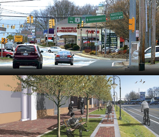
The junction of Kingstown Road and Old Tower Hill Road in the village of Wakefield, so familiar to URI alumni, is like any number of intersections across America: a frantic hive of asphalt, concrete, and backed-up vehicular traffic, where jittery pedestrians and bicyclists must survey eight lanes of travel if they dare to cross the street.
As the commercial hub of this town of 31,000, the busy crossroads hosts enterprises that attract a steady stream of consumers—a supermarket and pharmacy, restaurants and coffee shops, a liquor store, bank, and many other businesses—as well as providing access to neighboring Narragansett and to Route 1, one of the state’s vital north-to-south highways.
“To walk from old Wakefield to Dale Carlia Corners is quite an experience,” said Vincent Murray, the town’s planning director, who is an avid walker. “The intersection has long awaited a design that promotes safety for pedestrians.”
 “Our environment is so stressed, we have to think of ourselves as restorative, not designing only for aesthetics. You take good science and good design, and create a vision to solve problems.”
One graduate of the URI landscape architecture program is Catherine Weaver ’82, BCA ’96, who now operates her own design firm, Tupelo Garden-works, in North Kingstown. Her mission: create landscapes that include the work of local artisans and that bring her clients closer to their natural environment.
Tupelo Gardenworks won the contract to transform the outdoor courtyard at South Kingstown High School, based on a 2011 URI Senior Design Studio project titled “Re-Visualizing the Rebels.” Currently under construction, it will become an interactive home for outdoor classroom space and demonstration gardens, with native plant species, permeable walkways that allow rainwater to percolate into the soil, and locally made solar panels.
Weaver, whose peers have chosen her as president of the RI Nursery & Landscape Association (she’s also on URI’s alumni board), said that in a time of disappearing federal and state investment, increasing climate change, and concern for community welfare and the prudent use of resources, the role of landscape architects is more important than ever.
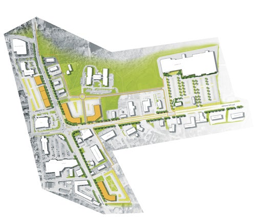
The challenge is one of several tackled by URI’s landscape architecture department. Under the guidance of Department Chair William A. Green, Professor Richard Sheridan, and the rest of the faculty, URI landscape architecture students completed a re-imagining of Dale Carlia Corners that won a 2013 American Planning Association Rhode Island Chapter award for “Outstanding Undergraduate Student Project.” It’s one of a series of groundbreaking studies and building proposals for some of South County’s most important neighborhood features, including an interactive, outdoor learning space at South Kingstown High School, a new Village Center in the adjacent rural town of Exeter, and the re-imagining of a 2.2-mile stretch of winding, narrow Kingstown Road (Route 108) from Kingston to Peace Dale.
These detailed proposals—engagingly written, generously illustrated with computer renderings, and based on rigorous analysis—are published by the students of the Senior Design Studio. It’s a methodology created by Green and intended to provide the students with full immersion in the highly complex and politically contentious world of 21st-century design and implementation.
“We teach how to have a career in landscape architecture in the private sector,” Green said recently, relaxed behind a desk covered with folders, binders, news clippings, recent trade publications, and new textbooks. He likes to keep current. “We’re training them in design, but they’re also learning plants, soils, hydrology, and all the technology required to get a job. Methods, materials, grading and drainage and roads—key elements in landscape,” Green said.
For town planner Murray, the partnership with URI students begins a public discussion to identify the nature of the problems at Dale Carlia, and to pose a range of solutions and improvements. The key word is public. Without the participation and support of the Corners’ many business owners, a host of town and state boards and officials, and, most importantly, town residents, nothing can be accomplished.
“The students’ perspective generated a lot of new ideas for property owners and the town to take a look at and apply over time,” Murray said. “This is a positive partnership for both sides.”
Maria Mack, chair of the South Kingstown Planning Board, agrees—noting that the Dale Carlia Corners project is the third collaboration between the town and the University’s landscape-architecture students.
“The students are unencumbered by the regulatory environment, unlike us,” Mack said. “They have the freedom to think outside the box, and that allows us to see in a different fashion.”
The first thing Green did was get his students out of the classroom. Their study of Dale Carlia Corners began in October 2012 and included consideration of the intersection’s history and place in the culture of the local community, along with a visual analysis of its many constructed and few natural features. The goal was to focus on the layout of the site and come up with ways to make it look better and function better, while helping both the resident businesses, drivers, and pedestrians.
Once you get out of your car and actually look at Dale Carlia, a lot becomes apparent.
Completely covered by asphalt and concrete, the only place for rainwater to go is into town storm drains and through underground sewer lines. Not a drop of that “gray water,” as it’s called, is reclaimed for use. That also means that all of the soil under that impermeable carapace is dead, deprived of water and sunlight.
The death of an 88-year-old Wakefield woman who was struck while trying to cross in November 2005 led the state Department of Transportation to install new pedestrian safety measures. In addition, a pair of “No Right Turn on Red” signs were installed on two of the four corners. However, on any day of the week, an observer standing in the nearby pharmacy parking lot can see that the signs are routinely ignored by drivers, who sail through the red light, sometimes while talking on cell phones. Not surprisingly, the sidewalks are usually empty, and bicyclists are rare.
Aesthetically, Dale Carlia is a hodgepodge of commercial design styles and in-your-face signage, bereft of trees, grass, and plantings. Though it is the most-viewed intersection in Wakefield, drivers and pedestrians see nothing that links the area architecturally to the older sections of Wakefield and neighboring Peace Dale. There is nothing to mark it as a village center.
The students also found that there is a curb cut marking an entrance or exit for a business an average of every 23 feet, baffling some drivers and making for an endless parade of vehicles pausing to turn from or enter a lane of travel—and compounding the danger to pedestrians.
As their research continued, the students conducted a charrette at the Town Hall as a way to encourage public comment. The results were eye-opening and informed the group’s final recommendations. Some of the changes would require redevelopment of present land parcels, but others are quite simple:
• Bring more of a mixed-use residential presence to improve the economic base and to encourage walkable and bike-able sites.
• Reduce the amount of paved areas by introducing bio-swales—wide strips of green plantings—and rain gardens to absorb and filter rainwater run-off. Students projected that increasing vegetation by four acres will prevent 430,000 cubic feet of water from entering the storm-sewer system each year.
• Add plantings to make building facades and parking lots more attractive and user-friendly.
• Add bicycle lanes, widen sidewalks, install benches, and improve lighting.
Ultimately, the goal is to make Dale Carlia a place where residents and visitors feel welcome and safe, while improving the area’s relationship with a natural ecosystem.
“Dale Carlia is a perfect opportunity, with so much potential,” Mack, the Planning Board chair, said. “It’s the perfect place to show that you can improve water runoff and water quality, and improve the look and feel of the commercial area. Businesses do not have to be ugly. We can make things better for everyone.”
Looking at the proposals for South County that the students of URI’s landscape-architecture Senior Design Studio have developed in recent years, it’s not hard to imagine a unified network—a “sense of place”—of bike paths and broad sidewalks, linking the architectural imagination of the past to the commercial and residential reality of the present.
What’s harder to imagine is harnessing the political will to get it done. But teachers, students, town and school officials, and landscape architects agree that it can be accomplished—and that these student proposals are essential ingredients in the broader public discussion that must take place.
—Jerry O’Brien ’81