Villages Beneath the Sea
It’s wet and blustery work uncovering the secrets of the Paleolithic villages that succumbed to sea-level rise at the end of the last ice age. Long commemorated in Narragansett tribal history, the ancient coastal settlers are now studied by underwater archaeologists, providing a glimpse into our distant past—and a model for future research.
BY JOHANNA KNAPSCHAEFER
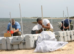
It’s 9:15 a.m. on June 23. Beneath a bright but hazy sky, the winds are whipping above rough surf when two vans and a yellow box truck arrive at West Beach on Block Island, a 10-square-mile lump of morainal deposits off the southern coast of Rhode Island. The team of 10 researchers wastes no time unloading diving gear, the Lego-like pieces that will make up the research vessel, and eight-foot-long plastic tubes for collecting core soil samples.
“The weather’s iffy today, but the water visibility is good, so we should be able to do some diving and coring up at the pond,” says David Robinson ’90, marine archaeologist at URI’s Graduate School of Oceanography, raising his voice above the pounding surf at the tailgate briefing. “Safety is everything, so be very careful carrying gear down the beach. It’s easy to twist an ankle on the cobbles.”
The team—including three researchers from the federal Bureau of Ocean Energy Management, two URI student members of the Narragansett Indian tribe, and three other URI students—have come for their first full day of fieldwork. They’re here in search of old land forms beneath the present-day coastal waters, markers that they hope will lead them to ancient Narragansett relics. Robinson and the divers are studying the history of human habitation, while URI professor of marine geology John King and his team are studying environmental factors that could have affected native people living in this area.
The aim is to shed light on how the earliest Native Americans lived during the Paleo-Indian period, a span of time that ran between 12,000 and 10,000 years ago and encompassed massive ecological change. The final glacial episodes of the late Pleistocene period had tied up vast quantities of water in ice sheets, making sea level at the beginning of the Paleo-Indian much lower than it is now. What is now the continental shelf was an open and grassy plain. But then, roughly 11,000 years ago, the ice melted and the seas rose.
“Block Island is a unique site because increased coastal erosion from modifications to the breakwater at New Harbor has exposed a previously buried submerged paleocultural landscape,” King says. “We can study the landscape here without time-consuming excavations.”
No one knows how long it took for the waters to rise, although tribal memories provide clues. “More than 15,000 years ago, Narragansett tribal ancestors lived out where the ocean is now, but had to suddenly abandon their homes when the ocean rose overnight.” That was the oral history told by the late Ella Sekatau, a Narragansett elder medicine woman, according to Doug Harris, preservationist for ceremonial landscapes for the Charlestown-based Narragansett Indian Tribal Historic Preservation Office in Charlestown, R.I. Harris presented it at the first stakeholder’s meeting of the Rhode Island Ocean Special Area Management Plan in 2010.
While oral history does not provide specific details of how the Narragansett ancestors lived 15,000 years ago, it reveals that tribal people hunted large animals including deer, elk, moose, bison and bear, in addition to rodents and other smaller animals. “And it is safe to conclude they were harvesting fish and sea mammals available along the coast,” Harris says.
The Block Island fieldwork is part of a $2 million project, funded by the Bureau of Ocean Energy Management, titled, “Developing Protocols for Reconstructing Submerged Paleocultural Landscapes and Identifying Ancient Native American Archaeological Sites in Submerged Environments.” King, Robinson and Harris are jointly leading the project, making it the first marine archaeology fieldwork in the nation to involve an American Indian tribe as a full research partner.
In five study areas—including Block Island, Narragansett Bay and Greenwich Bay—the team is developing standardized best practices for identifying ancient Native American submerged cultural resources. This will assist the federal government, U.S. states and tribal communities in evaluating proposed offshore wind-energy projects during development on the Outer Continental Shelf. Now in its second year, the four-year project has created a unique intersection between the oral history of the Narragansett Indian Tribe—the state’s only federally recognized tribe—and scientific research at URI.
“This project is of great significance for the Narragansett Tribe because it verifies our oral history,” Harris reflects. “It will help us protect that which is presumed to be out there, based on oral history—and scientific reality.”
After the tailgate briefing, everyone pitches in to haul the gear and supplies to the two fieldwork locations north of West Beach. As the divers gather up their gear, Robinson looks up at the opaque sky. “Make sure we have the emergency oxygen kit—we’ve got bad storms coming,” he shouts.
I grab a large cooler full of lunch fixings and begin lugging it down to the shore, moving from one cobblestone to the next, trying to keep my balance. My role is to report about the team’s research, but there is much work to be done before the fieldwork can begin, so I pitch in. Behind me two students are carrying the research vessel, which is basically a raft constructed of six interlocking pieces. “Let’s turn it longways so we’re not walking backwards,” one of them commands as they struggle to keep their footing in the sand.
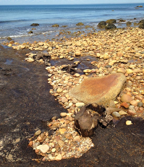
As I near a bend in the shoreline, Robinson approaches me from the opposite direction. “Now is a good time to see the stump, before the tide comes in,” he hollers before disappearing down the beach.
Stump? While scanning the beach, a huge driftwood log about 50 feet ahead comes into view, but I’m not sure that’s what he means. Then Chali Machado ’18, an anthropology student at URI and one of the divers, approaches, and I ask her to explain.
“He must mean the old stumps you can see near the shore,” she says. “I’ll show you.”
As we walk, she tells me a little about her involvement with the project and what it means for her Narragansett Tribe. Both she and her brother, Norman Machado ’18, are undergraduate students of cultural anthropology at URI and Native American partners in the project. They have conducted similar archaeology research on land in Charlestown, R.I.
“We want to bridge the gap between science and oral history,” Machado says, her long black dreads blowing in the wind. In her work for URI and the Narragansett Tribe’s Historic Preservation Office, she says she considers herself an advocate for her tribe and feels a responsibility to help educate Native Americans about the importance of land preservation. “A lot of elders and tribal people don’t trust science,” she explains.
“Native Americans bring knowledge that gives a more holistic view of how to interpret our findings,” says marine archaeologist Robinson. “And their spiritual and cultural connection adds powerful relevance to the project. We are combining science as one lens with the tribal view of the past, for a more complete explanation of how the first Narragansetts lived.”
Pointing toward the water where foot-high waves are crashing on the shore, I see a shiny brown tree stump jutting about a foot and a half out of the water. Behind it someone has built a cairn out of sand-polished rocks to mark the location.
“When the tide is lower, you can see three of them,” Machado explains.
The visible stump, Robinson says, has been radiocarbon-dated at 300 years old. The oldest of the trio, further away from the shore, is 800 years old.
“The tree stumps stand in their original growth position—the roots extend down into the soil and sedimentation,” Robinson says. “Trees don’t grow in the ocean, so this tells us the landscape was once very different here.”
Driven by Wind Energy
The uptick in offshore wind farm development, especially in the Northeast, has piqued interest in submerged landscapes on the continental shelf.
“Best practices for offshore wind developers conducting surveys would be useful to avoid or mitigate damage or destruction of ancient Native American archaeological sites listed on the National Register,” says Jeffrey Grybowski, chief executive officer of Deepwater Wind, Providence, R.I. The firm’s 30-megawatt, five-turbine Block Island Wind Pilot Project—the nation’s first offshore wind test farm—is now under construction three miles southeast of Block Island. It is one of three projects to win federal development rights for wind farms in the area between Martha’s Vineyard and Block Island; the largest is still in the planning phase but could be much bigger, at up to 200 turbines.
Rhode Island is ahead of its coastal sister states in getting ready for the influx of offshore power generation. Three prior studies, all conducted within the past eight years, have created a wealth of accumulated data: the Rhode Island Sea Grant Map, which mapped 95 percent of the Narragansett Bay system; the Special Area Management Plan, which mapped the seafloor and the ecology of a 1,467-square-mile area of ocean around Rhode Island especially to create a tool for managing offshore renewable energy development; and geological coring studies completed by Deepwater Wind in 2011. Robinson and his coresearchers hope their project will help fill in the gaps.
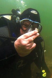
“With the advent of digital technology and applications for ocean surveys, we have the ability to work with digital data to reconstruct old landforms in ways we never could before,” Robinson says. “This is our best opportunity to understand how sea-level rise has impacted paleolandscapes.”
By 10:30 a.m. on this blustery morning, Robinson, two research divers from the Bureau of Ocean Energy Management, and Chali Machado are on the beach preparing for their dive. They check their valves, hoses, and gauges, before laying out their wetsuits to slide into them. By 11 a.m. they are fully suited and have adjusted their weight belts. “Let’s get in and get oriented to the landscape,” Robinson says.
The team is using GPS to map the extent of different types of soil on the ocean floor: peat, loess—the wind-blown sediment blown off glaciers when they recede—and any subsoils trapped beneath them. “As sea level rose, the shoreline receded, leaving a layer of peat on the soil,” Robinson explains. “We want to see how far they go offshore. But when the sea level rises and things go underwater, powerful waves and currents destroy most of the land surface, so finding undisturbed areas is challenging.”
Once the divers disappear underwater, I walk another quarter of a mile up the beach. The North Lighthouse is visible in the distance. On the way I pass Norman Machado and Doug Jones, a tribal liaison representative at the Bureau of Ocean Energy Management, both clad in wetsuits and walking through whitecapped water that approaches their chests. They are floating a raft laden with coring tubes and rods up to the shore near Wash Pond, a small freshwater kettle pond—likely formed by a retreating glacier—that King says could be 15,000 to 16,000 years old.
Once the team arrives with the coring equipment and the last of six rafts, it is well past noon and the weather has become uncomfortably hot. The team finishes inserting rods into the coring tubes and assembling the rafts to create one large interconnected barge.
“Has anyone checked the phone for radar lately?” King asks, his face mostly hidden beneath his safari hat.
“Looks like the weather is all pretty far north of us,” replies Casey Hearn ’17, a URI oceanography doctoral student.
“I don’t see any imminent threat,” King says before floating out to measure the depth of the pond at 7.5 feet. Cricket song rings through the blades of the tall Phragmites grass around the pond.
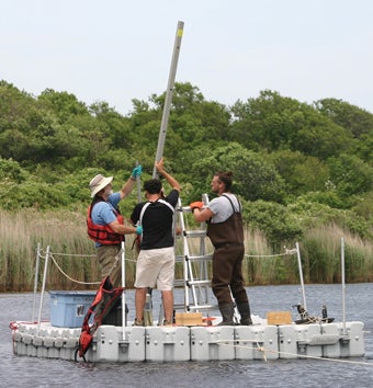
After filling one tube with pond water, the team lifts it onto the raft and places it into position before sinking it down through a hole in the deck. Next, Hearn climbs a ladder to attach an extension to the coring rod, then inserts a horizontal bar for leverage. Three of them grab the horizontal rod and push with all their might to suck up 10 liters of pond floor. King takes a quick read of the “layer cake sample,” which includes fossil vegetation at the top, a layer of mud, then a layer of sand at the bottom.
“The sand indicates a big storm with an overwash event,” King explains. “I think we’ll get a good radiometric date and match it up with the hurricanes. There were big hurricanes in 1938 and 1954.”
As the work draws to a close, Narragansett preservationist Harris pauses for a moment to think about his tribe’s future. “By being part of the scientific process, the Narragansett tribal project partners will receive training,” he says, “and be on the cutting edge of marine archaeological research in 10 to 15 years.” •
 Home
Home Browse
 Close
Close Events
 Maps
Maps Email
Email Brightspace
 eCampus


